
Amazing Aerial Images of Earth
The contours, shapes and colours that the topography the Earth's surface forms are breathtaking marvels.
Everyone knows that distance makes the heart grows fonder - and this notion now applies to the eye as well. The contours, shapes and colours that the topography the Earth's surface forms are breathtaking marvels not rivalled by any manmade images.
Yet they are only truly visible from well above the Earth. Seeing the world from this mesmerizing angle puts the insignificance of humans, when compared to Earth's enormous size, into perspective. Here are some of the most magnificent aerial images of our planet.


Guy Laliberté's Space Travels
The mastermind behind Cirque Du Soleil, Guy Laliberté travelled on board a Russian Soyez Rocket through space in 2009. While the billionaire was on this trip, he did a bit of sightseeing and documented some of the stunning scenery of the Earth that he was privy to.


David Maisel's Vertiginous Vistas
David Maisel certainly knows how to poignantly capture the most fascinating and mystifying regions of the world from the vantage point of his four-seater plane. Sometimes the photographer even removes an entire window from his plane - which gets to altitudes between 5,000 and 12,000 feet - to secure that perfect shot. But looking at these two examples we can safely say the effort is well worth it.

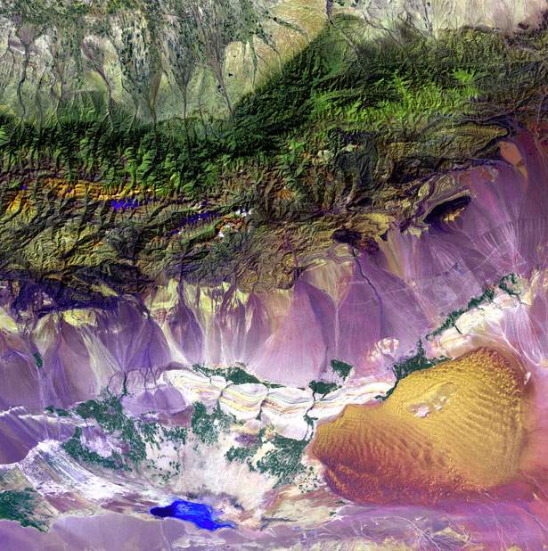
Landsat 7 Satellite Images
These two stunning images depict the Bolivian deforestation and the Bogda Mountains in China. The former shows the destructive impact that deforestation can have on native forests by severely fragmenting the ecosystem, while the latter illustrates the mesmerizing mix of sand dunes and salt lakes of the Turpan Depression laying at the foot of China's mountain range.


River Deltas Around the World
Water not only serves as the major life source for all living things on Earth, but the patterns it creates when travelling in estuaries throughout the world also create enchanting images. These two photographs depict such beauty from the Betsiboka Estuary in Madagascar and the Ganges in Bangladesh.


Satellite Photos of the Earth
These enthralling images were also taken from a satellite from outer space. The vibrant colours of these terrains almost appear to be oil pastels, yet they have emerged from genuine landscapes of the Earth. The first shows the icy blue transposed against the blood red in the Malaspina Glacier of Alaska and the second shows the twists and turns of the water and land in our very own Carnegie, Australia.


Earth from Above
These photos appeared on the Flickr page of a photographer by the name of curiouser*curiouser. Both images were taken over the Zion National Park in Utah from the seat of an aeroplane traversing the region. The parks appear so much more unique and beautiful from this high vantage point, featuring ripples and explosions within the Earth's surface.


- A Beginner's Guide to the Greek Islands
- Eleven Films and TV Shows You Need to Stream This Month
- Hop to It: 16 Classic and Eclectic Films You Can Stream This Easter Long Weekend
- Nine 2024 Oscar-Winning Films That You Can and Should Watch Immediately
- Say Cheers to Hollywood's Night of Nights: Concrete Playground's Oscars 2024 Drinking Game
- Predicting the Oscars: Who Should, Could and Will Win at the 2024 Academy Awards