Queensland to Be Hit With Wet and Wild Weather as Cyclone Approaches
While Tropical Cyclone Oma isn't expected to hit land, it will cause lots of rain and gale force winds across Brisbane and the southeast coast.

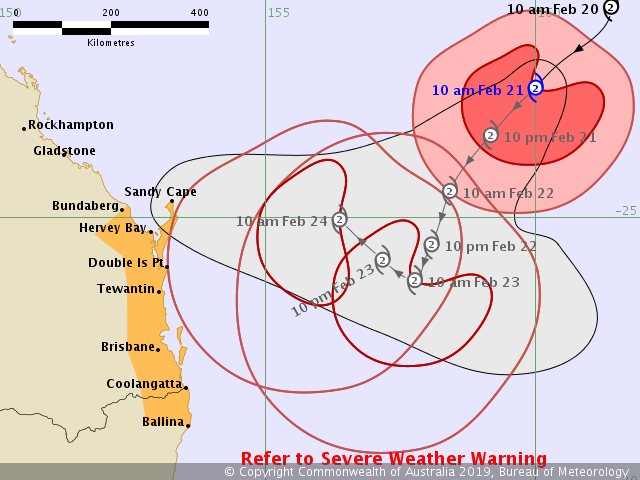
Wet and wild isn't just the name of a southeast Queensland water park. Thanks to Tropical Cyclone Oma, it might describe conditions across the state's lower coastline over the next few days. The Category 2 storm is currently approximately 890 kilometres north-east from Brisbane, prompting the Bureau of Meteorology to put everywhere from Bundaberg to Ballina on cyclone watch — including Brissie and the Sunshine and Gold coasts.
It has been 29 years since Cyclone Nancy threatened Brisbane, and while Oma isn't expected to make landfall in the near future based on present observations, it still looks likely to make its presence known. Currently sustaining winds of 95 kilometres per hour — and wind gusts reaching 130 kilometres per hour — BOM predicts that the storm will keep moving in a general southwesterly direction. Travelling at 11 kilometres per hour, it'll head towards the southeast Queensland coast across Thursday and Friday, all while maintaining its current intensity.
Bureau of Meteorology
Think wind, rain and generally staying away from waterways — plus planning your next moves if the cyclone threat increases, which is a course of action that the Bureau strongly recommends. There's already more than a brisk breeze blowing, and mild-to-heavy showers are forecast for the next six days, including up to 60 millimetres on Sunday and up to 50 on Monday. Temperatures will also dip slightly, hovering at the 28-degree mark compared to today's top of 34.
Brisbane mightn't seem like cyclone territory; however, both of the city's 1893 and 1974 floods were actually the result of cyclonic weather systems — and the latter was caused by a slow-moving cyclone, like Oma. Starting in Fiji and gradually making its way towards our shores, Oma has been dubbed a "large-eyed" storm by NASA, who anticipate the cyclone moving west to northwest by the end of the weekend.
On the coasts, as well as the Fraser Island and Wide Bay coast, the Bargara region and even northern New South Wales, Oma is also due to spark heavy rainfall, coastal erosion, dangerous surf conditions, gale-force winds and larger-than-usual high tides. If you're wondering what kind of big waves are in store, BOM advises that it "may exceed the highest tide of the year by around one metre". With that in mind, all beaches on the Gold Coast are closed from now until Sunday, February 24, and some spots on the Sunshine Coast are too. In general, residents are warned to avoid all coastal activities, including rock fishing, boating and swimming. And, obviously, to not even dream about living out any Point Break-style 50 year storm surf fantasies.
With a toasty warm January proving Australia's hottest month ever on record, and with floods savaging Townsville earlier this month, 2019 has already proven a tumultuous time, weather-wise, in Queensland. That doesn't look set to change any time soon. Stay safe and dry, folks.
The Bureau will continue to update its warnings and maps regularly — visit bom.gov.au/qld/warnings/.


- Dark Arts, Hedonism and Exploration: A Weekender's Guide to Visiting Hobart for Dark Mofo
- The Best Australian Fashion Labels to Know Right Now
- CP Picks: The Best Gifts for People Who Are Never Home — According to Travel Writers
- The Ten Best Hotels in Brisbane
- The Nine Best Coastal Spots for Whale Watching Across Australia
- The Best Pubs in Brisbane for 2026