Overview
Australia is wrapped in tens of thousands of beaches — is it really possible to choose a definitive list of the best? When it comes to New South Wales, it's icon after icon. Along the coastline, there's a whopping 892 recorded beaches, some are known all over the world (looking at you, Bondi), while others are preciously guarded local favourites.
When it comes to choosing favourites, we have our own opinions when it comes to the best beaches in Sydney, but there's a lot more ground to cover. For that, we've turned to the travel experts at Lonely Planet, who shared with us their selections — which you can read in full in the newly published Best Beaches Australia guide.


Shutterstock
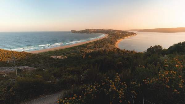
Zenith Beach, Port Stephens
Soaking up the panoramic coastal views from the 161m (528ft) summit of Tomaree Head is a quintessential Port Stephens experience. Directly below is one of several glorious beaches naturally carved from this rugged stretch of coastline north of Newcastle/Muloobinba, perfect for cooling off after the steep hike up Tomaree Head. Framed by ancient volcanic headlands cloaked in the native forests of Tomaree National Park, unpatrolled Zenith Beach feels deceptively remote – Shoal Bay, the closest village, is less than 1km (0.6 miles) down the road.
Just 120m (394ft) from the car park, its clear waters beckon confident swimmers and surfers, with June to August bringing the best waves and whale‐watching opportunities. Dolphins are frequent visitors, and an array of birdlife can be seen here throughout the year. Zenith Beach also marks the beginning of the Tomaree Coastal Walk, a three‐day, 27km (17‐mile) walking adventure linking secluded beaches, coastal villages and koala habitats on Worimi traditional lands.
Getting there: Zenith Beach is 220km (137 miles) or nearly three hours' drive north of Sydney/Warrane. The 130 bus from Newcastle to Fingal Head stops at Zenith Beach, via Nelson Bay.

Shutterstock
Broken Head Beach, Broken Head Nature Reserve
The long and wild beach stretching 7km (4.5 miles) south from the historic Cape Byron Lighthouse comes to a dramatic end at Broken Head Beach. Surrounded by the coastal rainforest of the Broken Head Nature Reserve, 'Broken' remains largely unchanged from the beach that road‐tripping surfers 'discovered' in the 1960s; a small caravan park is the only beachside development and limited parking restricts crowds. A long, hollow right‐hander peels around the rocky point in the right conditions (look for a southeasterly swell with a southwesterly offshore wind) and there are rock pools to discover at low tide.
Follow the 1.6km (1‐mile) return Three Sisters Walking Track around the headland for glorious views and to learn about Broken's significance to its Arakwal Traditional Custodians. Known as the Three Sisters, the series of rocky outcrops rising from the water beyond the headland tell the story of three sisters turned to stone by their ancestors. They're a warning to future generations about the importance of respecting cultural traditions – and to take care at this beach patrolled only in the summer school holidays (late December through January).
Getting there: Located on the New South Wales North Coast, Broken Head Beach is 9km (5.6 miles) or a 15‐minute drive south of Byron Bay.

Shutterstock
Hyams Beach, Jervis Bay
It's often described as having the world's whitest sand (a 2006 study found Western Australia's Lucky Bay to be even whiter), but there's no denying that Hyams Beach is as white as the waters of the vast Jervis Bay are blue. The contrast between its snow‐white sand and the over‐exposed gradient of blue water darkening into the depths made Hyams so social‐media famous that in 2019 the local Shoalhaven council appointed traffic controllers to redirect visitors from the tiny Hyams beach village.
As you may have guessed, this is a beach best avoided during the summer (and autumn and spring) school holidays, especially weekends. Aim for a windless, off‐season weekday, and you won't just have a better chance at scoring a parking spot – Hyams' dreamy blues will beam you straight to heaven on Earth. Bring a snorkel and look for groupers and stingrays at the northern end of the beach, known as Little Hyams.
Getting there: Hyams Beach is 200km (124 miles) or around three hours' drive south of Sydney/Warrane. Park at Greenfield Beach and take the White Sands Walk (1.7km/1 mile) to Hyams Beach, which takes you past the similarly sublime Chinamans Beach.

Getty Images
Emily Bay, Norfolk Island
Aat first, this small Australian island looks like a chunk of New Zealand's bucolic North Island that has broken off and drifted 1100km (683 miles) north. But despite being only 8km (5 miles) long and 5km (3 miles) wide, Norfolk Island is vividly, defiantly, more than just a Mini‐Me of its two largest neighbours. For one thing, its history reads like an epic adventure tale: from the seafaring Polynesian settlers who called the island home from 1200 to 1600; to two brutal convict eras, during which Norfolk became known as the 'Hell in the Pacific'; to the arrival, in 1856, of 194 Pitcairn Islanders descended from HMS Bounty mutineers and their Tahitian families, whose culture and language still infuse daily life on Norfolk.
Ringed by high volcanic sea cliffs and surrounded by deep ocean trenches and undersea mountains, Norfolk Island is also ruggedly natural. There's a national park, multiple walking trails, and a botanical garden. The eponymous pine trees grow everywhere; even the main settlement is called Burnt Pine. And because of strict biosecurity regulations, most of Norfolk's food is grown, caught, foraged or made on the island, even coffee and wine.
It all comes together at Emily Bay. One of the island's best swimming beaches – and picnic spots – just happens to be within the Kingston UNESCO World Heritage Site, surrounded by Norfolk Marine Park. It's a stone's throw from the ruins of the island's notorious penal settlement, and includes a pier, boathouses, prisoners' barracks and a cemetery overlooking the sea. You can swim in water that's as clear as a glacial stream but warm all year round, because Norfolk lies at the same latitude as Byron Bay in Northern New South Wales.
The sandy beach isn't patrolled, but low headlands partially enclose the bay, keeping its waters calm and family friendly. Swim out a little way and you can even snorkel over a coral reef, though the snorkelling is arguably better at neighbouring Slaughter Bay (which is more inviting than its name). A turquoise lagoon fringed by coral, its temperate and tropical fish like wrasse and parrotfish are known to swim right up to your mask.
Getting there: Norfolk Island is 1400km (870 miles) east of Byron Bay. Flights to the island depart from Brisbane/Meanjin, Sydney/Warrane and Auckland. Emily Bay is 5 to 10 minutes' drive from the main township of Burnt Pine (be mindful of the island's cows, which have right of way).

Shutterstock
Number One Beach, Seal Rocks
The first beach you see on your left as you drive into the hamlet of Seal Rocks, Number One is a north‐facing beauty with a gentle right‐hand point break at its eastern end, and calm waters ideal for families. The caravan park is just across the road, there are picnic tables and an accessibility ramp. Up and over the hill, past Seal Rocks' only shop, lies Boat Beach, where tractors launch small fishing boats straight off the sand.
It's ideal for both swimming and snorkelling; the three‐hump rock island just off the beach is a sanctuary for grey nurse sharks. And just south of Seal Rocks, a gravel road leads to three more beaches popular with experienced surfers: Lighthouse (Sugarloaf Point Lighthouse stands at its northern end), Treachery (synonymous with its sprawling family‐owned campground behind the dunes) and Submarine Beach (named after a 1945 Dutch submarine‐wreck), also called Yagon after the national park campground located at its northern end.
Getting there: Seal Rocks is a tiny town encircled by Myall Lakes National Park, 239km (148.5 miles) north of Sydney/Warrane. The nearest train station is in Taree, on the Sydney–Brisbane XPT line. From Taree, it's about 90 minutes by car to Seal Rocks.

Shutterstock
Balmoral Beach, Sydney/Warrane
With more than 100 beaches to choose from in Sydney/Warrane, the city's excellent harbour beaches are often overlooked. Captured in the works of some of Australia's most prolific painters – from Arthur Streeton to Ken Done – unpatrolled Balmoral Beach is a special place for many Sydneysiders, and its calm waters popular with families. Separated from Edwards Beach by the tiny Rocky Point Island, the 840m (2638ft) arc of Balmoral Beach lies on the traditional lands of the Cammeraygal people of Sydney's North Shore, who have camped, hunted and feasted along this caramel sandstone coastline for generations.
A tramline from the city opened in 1922, improving access to Balmoral's enclosed bathing area built in 1899. A grand bathing pavilion, a rotunda for brass‐band concerts and a wide promenade was added in the 1930s. While the tram is long gone, the Balmoral Baths and the Art‐Deco rotunda and pavilion (now a celebrated restaurant) remain, adding an air of regality fitting for a beach named for Queen Victoria's Scottish castle.
Getting there: Buses from the city (Wynyard) take approximately 20 minutes to reach the junction of Spit Rd and Awaba St. From here it's a steep 600m (1968ft) downhill walk to the beach. There's limited beachfront parking.
These excerpts were supplied by 'Lonely Planet' from their 'Best Beaches Australia' guide — available online and at bookstores near you now.
Images: supplied